Saskatchewan’s forests cover a vast expanse of the province, but the magnitude of the details that classify, measure and describe our forest is even more grand, making technology vital to forestry professionals.
Just looking at a single tree, there are many pieces of information to be known about it, starting with its species, height and diameter. Forestry professionals regularly gather details about the trees in a forest, plus additional information about the ecosystem in which they exist. That includes being aware and considerate of other vegetation as well as water, wildlife and more. Each has its own set of data that can be collected.
That is the beginning of the volume of data to be collected and interpreted by forestry professionals when making decisions, which is why technology matters to this profession. Forestry professionals provide services related to developing, managing, conserving and sustaining forests. The technology forestry professionals use supports them when they make decisions that involve several complex and interconnected factors.

Technology also allows forestry professionals to work more efficiently and often reduces how they are exposed to safety risks, said Cam Brown, RPF, who works as a strategic planning forester for Forsite Consultants Ltd.
Collecting data about forests
Brown explains it is becoming more common to use technology to collect data about forests.
“We’re using new, data-driven approaches to creating forest inventories,” he said.
“That’s a transition that’s occurring now.”
“Before the approaches were very manual. A human was doing the interpretation by looking at a photo and saying, ‘Hey, that’s a stand of pine and it’s 22 meters tall.’”
Brown explains how technology has been introduced to field work done by those in forestry.
“When I first started doing field work, I’d use a yellow book with waterproof paper and would be making notes all day,” he said.
“Now people use iPads with custom built with mapping templates to allow them to draw and share information back and forth.
“They also use digital forms that are automatically synced computers back in the office when they come back to an area with Wi-Fi.
“That data collection, movement and processing is becoming much more streamlined and efficient than it ever has been in the past.”
Some of the other technology used for data collection include satellites and drones, which can provide forestry professionals valuable images.
“It’s giving you a better vantage viewpoint and instead of having to walk everywhere, you can fly the drone and get a look at what’s going on,” said Brown.
“We also have many sensors that help us describe the state of the forest at any given time.”
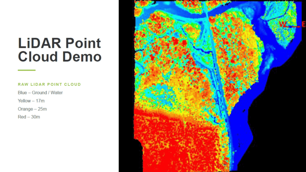
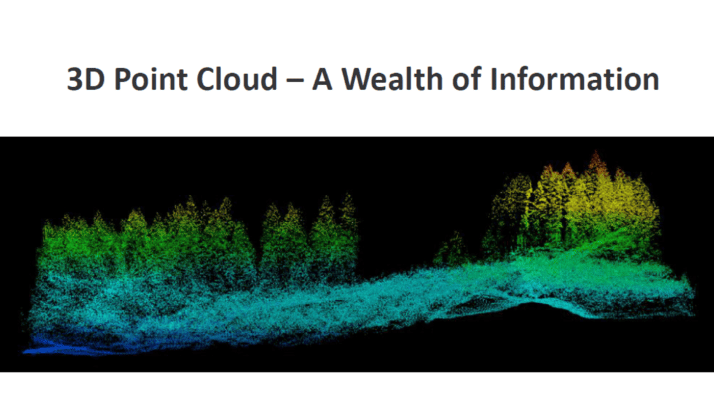
Another way that data is collected to create forest inventories is through light detection and ranging, known as LiDAR.
“A plane flies over the forest and shoots millions of laser beams down,” Brown explains.
“For every beam that gets shot down and bounces back, the speed of light is used to measure the distance from the plane and this generates a 3D point cloud representing everything the laser pulses hit (ground, water, vegetation, etc.)
“This point cloud gives you an incredibly accurate and detailed view of the forest and the ground below it.”
That data can then be used, for example, by machine-learning algorithms to identified individual trees and then predict the species those trees. Using technology is providing forestry professionals valuable data to use in their decision making.
“It’s just a huge amount of detail that was never really present in a lot of other previous inventory data sets,” said Brown.
Using technology to support decision making
The data collected about forests is used in forest management software.
This software models forests and possible future activities to help forestry professionals optimize their decisions about what areas of the forest to harvest and determine sustainable harvest relative to other objectives. Those objectives can be related to sustaining wildlife habitat, water quality/quantity, or biodiversity. They could also be related to community values or recreational uses.
“When we’re thinking about big-picture, long-term strategic decisions, those kinds of models help us make informed decisions,” said Brown.
“But at the end of the day, it’s humans that have to decide what makes sense on the ground and implement those activities on the ground.”
Brown has been working with the technology used by forestry professionals since he was a university student in the early 1990s. He studied forest engineering first at the University of British Columbia and then at Oregon State University. It was at these post-secondary schools that he developed his understanding of spatial landscape modeling with heuristics.
“When I first came into the workforce, I was one of the first to use that type of modeling in Western Canada,” said Brown.
Problem-solving techniques combined with technology tools can help humans work through very complex forest planning challenges in a structured way. In particular, models that help to solve spatial patterns on the landscape while also considering the need to maintain specific age class distributions are very useful to help planners how to achieve desired future forest conditions. These types of model typically require mathematical heuristics to find good solutions.
“A heuristic is basically an algorithm that works to find good solutions in the solution space.” Where the solution space is ‘What areas do I harvest? When do I harvest? and What treatments do I apply?’’”
He provides an example to explain.
“So, you’ve got a land base that is 200,000 hectares is size and you want to know what a sustainable harvest level is while also maintaining non timber values on that land. It becomes the analyst’s job to setup a model to grow and harvest trees over hundreds of years while also maintain the right kind of forest conditions that provide wildlife habitat, biodiversity, etc. Then you ask the model to schedule harvesting (which polygons get harvested by what type of system in what time period) in a sustainable way.’”
Technology to support engineering
Technology can also help forestry professionals determine how to best move the wood that has been harvested over the terrain where it is located. There could be an incline between that location and where the wood needs to be taken to begin its journey out of the forest.
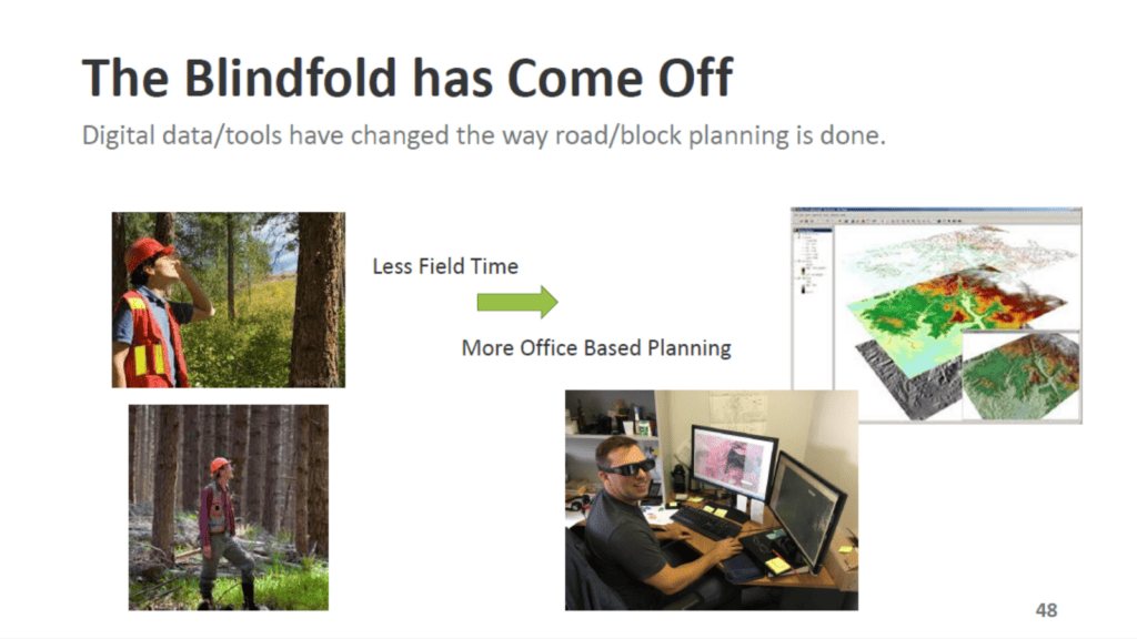
“Historically we would have had to send field crews out and they would have had to walk up and down this hill and survey it to get a detailed understanding of the terrain,” said Brown.
But by using LiDAR, Brown said the terrain can be understood in greater detail to inform the engineering that must be done to move the wood off the site.
“We can do a lot more from the office to understand what is on the ground today in terms of the trees, the terrain and the water,” said Brown.
“All of that information is just much, much more reliable now based on the LiDAR data.
“Therefore, foresters can do more planning in a GIS (geographic information systems) system and less time walking in the field to try to figure out what’s possible.” This makes the process more efficient and safer as field crews are more informed about the terrain they will be working on and they spend less time in hazardous conditions.
Technology’s role in reducing safety risks
“We’ll never get rid of the process of walking in the forest. That’s always critical to confirming what the technology is telling us,” said Brown.
“But field work is by far the most risky aspect of a forest management consulting business,” said Brown, describing some of the hazards they can encounter when walking through the forest.
“There are slip, trips, falls, eye pokes, wildlife encounters, vehicle accidents — you name it.”
“If we can reduce the amount of time and effort required in the field, then we have a better safety outcome as well.”
Combining an interest in technology with a career in forestry
Those interested in working in forestry can typically find a role that suits their particular interest.
“There is a role for every single skill in the forest sector,” said Brown, providing some examples.
“If you want to grow trees, you could work in a nursery.
“If you want to solve engineering problems, you can work on the design of harvesting blocks.
“If you’re an analyst, there’s modeling, statistics, and economic issues to be tackled.”
Being prepared to work with technology will be attractive to any employer looking to hire.
“If you have some inclination towards using apps and tools to make your job more efficient, that’s a real plus,” said Brown.
“If you can bridge those two worlds — do some basic technology stuff, but also enjoy the field work — that’s a real sweet spot for us.”
Those whose technology knowledge and skills are more advanced also have a a lot of opportunities right now, especially when combined with a knowledge of forestry.
“We produce products using data science and technology, but you have still to understand the forestry business,” said Brown, who points to one of his employees as an example of how one person developed the type of insight and experience that he values as an employer.
“One of the great hires I’ve got now earned an undergraduate degree in computer science, did tree planting in the summer, and then eventually went back and did a master’s in forestry.”
The Association of Saskatchewan Forestry Professionals provides a list of accredited schools and programs. When it comes to choosing one to specialize in the technology used by forestry professionals, Brown suggests looking at what each school has to offer.
“Most of the forestry schools provide basic levels of this technology understanding, but some have more sophisticated graduate degree programs,” he said.